Arbeitsbereich

Migration und Mobilität

Auf einen Blick Projekte Publikationen Team

Projekt

Impact of Human Mobility on Spatial Dynamics of Infectious Diseases

Daniela Perrotta, Egor Kotov; in Zusammenarbeit mit John Palmer (Pompeu Fabra University, Barcelona, Spanien), Frederic Bartumeus (The Spanish National Research Council, Blanes Centre for Advanced Studies, Spanien)

Ausführliche Beschreibung

Human mobility plays a key role in the spread of many infectious diseases. The impact of population movement on the likelihood of sustained local disease transmission is twofold: (i) with the growth of the transportation infrastructure and millions of people travelling every day, the chance of creating new routes and opportunities for disease vectors and pathogens to spread into new susceptible populations is higher than ever before; (ii) human mobility significantly affects the social contact and mixing patterns in the population, which in turn affects the interaction and disease transmission between susceptible and infected individuals. Timely, accurate, and comparative data on human mobility are therefore paramount for epidemic preparedness and response.

Vector-borne diseases are further aggravated by the spatial heterogeneity in the environmental and socioeconomic factors that modulate the exposure of the population to the vector itself. Modeling the spread of vector-borne diseases thus includes not only the human mobility but also the spatial distribution and abundance of vectors, as well as its spatiotemporal dynamics. Species distribution models are usually employed to predict species occurrence across space and time, but they rely on species suitability factors and omit the human mobility aspect. While vector species have a limited range of travel (e.g., 300 meters for tiger mosquitoes), the spread of the species (and consequently of the diseases they carry) is facilitated by human mobility. There is multiple evidence of vector species being transported by various forms of human transportation for both long distances and short distances (via plane and cars, respectively).

We investigate the potential benefits of different human mobility data for outbreak prediction, mainly focusing on the mobility patterns derived from digital traces and mobile phone activities, in comparison to more traditional data sources, such as census data and mobility models. Incorporating these mobility patterns into mathematical and computational models allows us to examine the potential impact of this type of derived human mobility in modeling the spatial dynamics of infectious diseases.

Using the 2015-2016 Zika virus (ZIKV) outbreak in Colombia as a case study, we have shown that even very aggregated information obtained by mobile phone data are sufficient to outperform the epidemic outcomes generated by traditional data sources or synthetic mobility models based on such data. This was quantified by means of a stochastic metapopulation model for vector-borne disease that we employed to simulate the ZIKV spread. Given the same modeling settings, we assessed the performance of each mobility network in capturing the ZIKV outbreak, both nationally and subnationally, as reported by the official surveillance data from Colombia’s National Institute of Health. Our evidence highlights the limited predictability in epidemic outbreaks in the absence of more refined and updated sources of mobility, such as aggregated mobile phone data, and provides a timelier and more accurate picture of the human mobility patterns needed to inform infectious disease models.

Menschliche Mobilität und der Ausbruch des Zika-Virus in Kolumbien

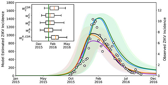
Vergleich von der ZIKV Inzidenz (pro 100.000 Einwohner) wie von der amtlichen Überwachung gemeldet (schwarze Punkte) und verschiedenen Netzwerken © Perrotta, D., Frias-Martinez, E., Piontti, A. P. y, Zhang, Q., Luengo-Oroz, M., Paolotti, D., Tizzoni, M., & Vespignani, A. (2022). Comparing sources of mobility for modelling the epidemic spread of Zika virus in Colombia. PLOS Neglected Tropical Diseases, 16(7), Article 7. https://doi.org/10.1371/journal.pntd.0010565

Das Diagramm zeigt den Vergleich zwischen der ZIKV-Inzidenz (pro 100.000 Einwohner), wie sie von der amtlichen Überwachung gemeldet wird (schwarze Punkte), und den Schätzungen des stochastischen Ensemble-Outputs für jedes betrachtete Mobilitätsnetzwerk, d. h. das CDR-informierte Netzwerk (blau), das Zensusnetzwerk (schwarz), das Schwerkraftnetzwerk (orange), das Strahlungsnetzwerk (violett) und das auf CDR-informierte Mobilität kalibrierte Strahlungsnetzwerk (grün).

Das eingefügte Diagramm zeigt die anhand der Modellschätzungen berechnete Spitzenwoche im Vergleich zur beobachteten Spitze in der Woche 2016-05 (grüne Linie). Während die Leistung der verschiedenen Mobilitätsnetzwerke auf nationaler Ebene vergleichsweise ähnlich ist, zeigt die Abbildung die gute Leistung unseres Modells, einschließlich seiner epidemiologischen Annahmen, bei der Erfassung der Ausbruchsdynamik ohne jegliche Anpassung an die beobachteten Daten. Weitere Einzelheiten sind in der Veröffentlichung zu finden.

Publikationen

Perrotta, D.; Frias-Martinez, E.; Pastore y Piontti, A.; Zhang, Q.; Luengo-Oroz, M.; Paolotti, D.; Tizzoni, M.; Vespignani, A.:
PLOS Neglected Tropical Diseases 16:7, e0010565–e0010565. (2022)    
Perrotta, D.; Frias-Martinez, E.; Pastore y Piontti, A.; Zhang, Q.; Luengo-Oroz, M.; Paolotti, D.; Tizzoni, M.; Vespignani, A.:
medRxiv preprints. unpublished. (2021)    
Das Max-Planck-Institut für demografische Forschung (MPIDR) in Rostock ist eines der international führenden Zentren für Bevölkerungswissenschaft. Es gehört zur Max-Planck-Gesellschaft, einer der weltweit renommiertesten Forschungsgemeinschaften.